How to Take the Subway in New York City
Before I delve into the details of how to take the trains, let me help you understand some of the basic information about the system.
What is the New York City subway system?
The subway system is the main public transportation system in New York. It is one of the oldest and largest public transportation systems in the world (in terms of number of stations). With some 5.5 million riders on a given weekday (before the coronvirus pandemic), it is one of the primary modes of transportation for the majority of New Yorkers and tourists. The system is operated by a subsidiary of the Metropolitan Transportation Authority (MTA).
The subway system is usually just referred to as the "trains." Locals say "I can take the train to your place" to generally mean that they take the subway. The subway is never referred to as the metro, underground, or tube.
Unless noted otherwise, I mean the subway system if I just use the word train by itself. While trains mostly run underground in Manhattan, a good portion of trains run on elevated tracks in the other boroughs. With some exceptions the whole subway system operates 24 hours a day, 7 days a week. It essentially never closes, except for major incidents such as hurricanes.
What is not the New York City subway?
While the subway system is the primary mode of transportation in New York, it is not the only transportation system in the greater metropolitan area. Other large, train-based transportation systems exist in this area that you might confuse with the New York subway include the following:
- AirTrain JFK/Newark
- Amtrak
- Long Island Rail Road (LIRR)
- Metro-North Railroad
- New Jersey Transit
- Port Authority Trans-Hudson (PATH)
With the exception of the AirTrains, these trains are also referred to as "commuter trains" because commuters from outside New York take these to commute in and out of the city on a daily basis. This guide does not apply to any of these transportation systems.
To avoid confusion some locals refer to these transportation systems by their names. They'll say, "I'm taking Metro-North this weekend," "Let's take New Jersey Transit to the airport," or "I'm coming in from the PATH train."
Understanding New York City's geography
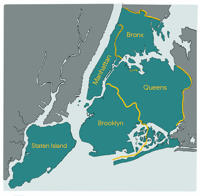
New York City is divided into five boroughs with Manhattan being the central area where the majority of tourist attractions reside:

The New York subway system operates in Manhattan, Queens, Brooklyn, and the Bronx. It never leaves New York City. You have to take one of the commuter trains mentioned previously to do so.
The boroughs are often used as a direction of travel for trains:
- Trains that travel towards Manhattan are Manhattan-bound trains
- Trains that travel to Queens are Queens-bound trains
- Trains that travel to Brooklyn are Brooklyn-bound trains
- Trains that travel to Bronx are Bronx-bound trains
The Staten Island Railway is a separate train system that runs on Staten Island only. Even though it is often depicted on the New York subway map, there does not exist a physical connection between the two systems. You have to take the (free) Staten Island Ferry or cross the Verrazano-Narrows Bridge in a car to get to Staten Island. However, the system operates on the same fare system as the regular subway system: there is a free transfer between the two systems (you pay only once in one system, and the second swipe with the same farecard within two hours will be free in the other system).
Manhattan's street grid
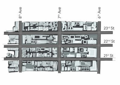
The street system in Manhattan is famously composed of a rectangular street grid. Streets (abbreviated as "St") travel east and west, while avenues (abbreviated "Ave") travel north and south. (This is not entirely accurate, since the grid system is not perfectly aligned with the directions on the compass.) Street numbering increases as you go further north, while avenue numbering increases as you go further west:

This grid system is not perfect. For instance, 4th Ave is named Park Ave for most of its stretch and the grid system does not really exist below 14th St for historical reasons. The rectangular area that streets and avenues create in between are referred to as blocks and are also often used as a colloquial measure of distance. You might hear "the subway station is two blocks east" or "I have to walk three blocks to get to work". Because blocks are rectangular in shape, blocks can be "short blocks" (if you walk north-south along an avenue) or "long blocks" (if you walk east-west along a street). Long blocks are also referred to as crosstown blocks. It takes about 1 minute to walk a short block or 3-4 minutes to walk a long block. Keep this concept in mind as it will help you find subway stations and navigate maps.
Understanding Uptown, Midtown, and Downtown
Roughly speaking, Manhattan can be divided into three areas:
- Uptown (anything north of 59th St.)
- Midtown (between 59th St. and 14th St.)
- Downtown (anything south of 14th St.)

While Uptown, Midtown, and Downtown are geographic regions of Manhattan, the words uptown and downtown can also mean the direction of travel. If you head north (towards the Bronx or Queens), you are heading "uptown"; if you head south (or towards Brooklyn), you are heading "downtown." Locals rarely use the words "north" or "south" for that reason. We do however use "east" and "west" in Manhattan ("just walk two blocks east") even though it's not technically accurate. Navigating east and west is also referred to as "crosstown" as in "to get to the Upper East Side you have to take a crosstown bus through Central Park".
How to Take the Subway in New York City
Source: https://www.nycsubwayguide.com/subway/basics.aspx
0 Response to "How to Take the Subway in New York City"
Post a Comment